Half of Norway's population lives in the 23 largest of 357 municipalities
Half of Norway's population lives in the 23 largest of 357 municipalities
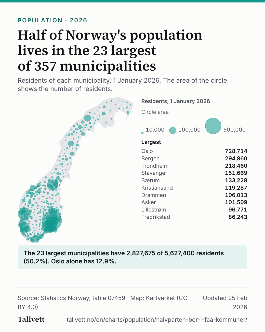
Residents of each municipality, 1 January 2026. The area of the circle shows the number of residents.
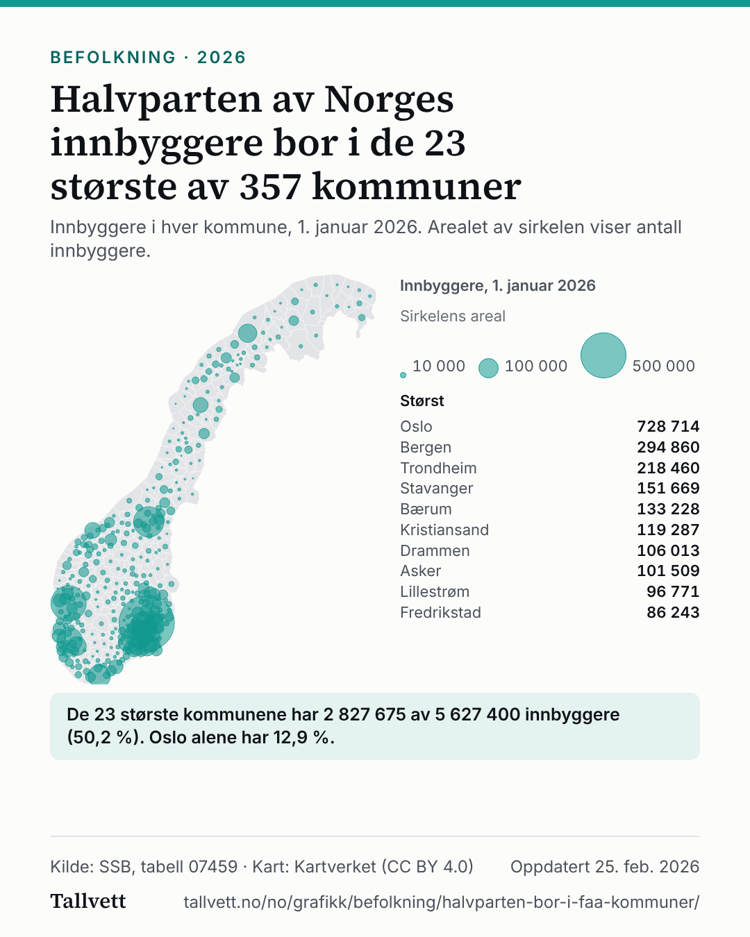
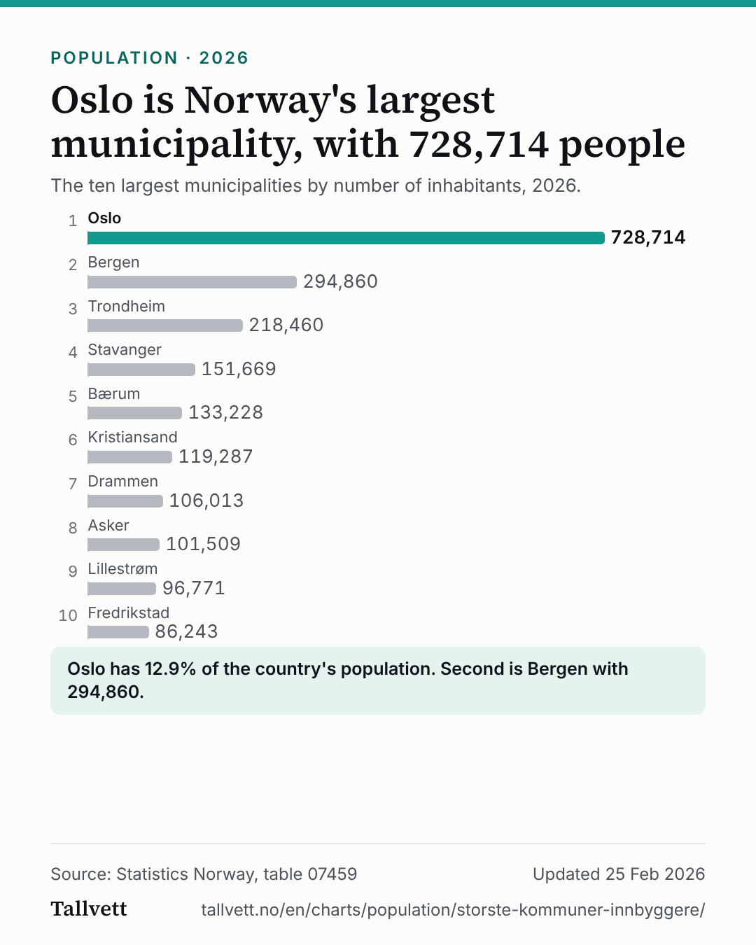
Map of Norway with a circle for each municipality, as large as its number of residents in 2026. Half of the country's 5,627,400 residents live in the 23 largest municipalities. The ten largest are Oslo (728,714), Bergen (294,860), Trondheim (218,460), Stavanger (151,669), Bærum (133,228), Kristiansand (119,287), Drammen (106,013), Asker (101,509), Lillestrøm (96,771), Fredrikstad (86,243).
Residents, 1 January 2026
Circle area
- 10,000
- 100,000
- 500,000
Largest
- Oslo728,714
- Bergen294,860
- Trondheim218,460
- Stavanger151,669
- Bærum133,228
- Kristiansand119,287
- Drammen106,013
- Asker101,509
- Lillestrøm96,771
- Fredrikstad86,243
The 23 largest municipalities have 2,827,675 of 5,627,400 residents (50.2%). Oslo alone has 12.9%.
Show the figures as a table
| Municipality | Residents |
|---|---|
| 1. Oslo | 728,714 |
| 2. Bergen | 294,860 |
| 3. Trondheim | 218,460 |
| 4. Stavanger | 151,669 |
| 5. Bærum | 133,228 |
| 6. Kristiansand | 119,287 |
| 7. Drammen | 106,013 |
| 8. Asker | 101,509 |
| 9. Lillestrøm | 96,771 |
| 10. Fredrikstad | 86,243 |
| 11. Sandnes | 85,785 |
| 12. Tromsø | 79,943 |
| 13. Sandefjord | 67,062 |
| 14. Nordre Follo | 65,381 |
| 15. Sarpsborg | 60,614 |
| 16. Tønsberg | 60,246 |
| 17. Ålesund | 59,663 |
| 18. Skien | 56,906 |
| 19. Bodø | 53,638 |
| 20. Moss | 53,207 |
| 21. Lørenskog | 51,511 |
| 22. Larvik | 49,022 |
| 23. Indre Østfold | 47,943 |
| 24. Arendal | 46,603 |
| 25. Ullensaker | 45,982 |
| 26. Karmøy | 43,990 |
| 27. Øygarden | 40,641 |
| 28. Haugesund | 38,663 |
| 29. Porsgrunn | 37,435 |
| 30. Ringsaker | 36,199 |
| 31. Hamar | 33,817 |
| 32. Molde | 33,291 |
| 33. Halden | 32,082 |
| 34. Ringerike | 31,942 |
| 35. Gjøvik | 31,350 |
| 36. Askøy | 30,600 |
| 37. Alver | 30,285 |
| 38. Lillehammer | 29,669 |
| 39. Sola | 29,541 |
| 40. Kongsberg | 29,169 |
| 41. Lier | 28,797 |
| 42. Eidsvoll | 28,739 |
| 43. Horten | 28,173 |
| 44. Færder | 27,743 |
| 45. Holmestrand | 27,086 |
| 46. Bjørnafjorden | 26,753 |
| 47. Nittedal | 26,032 |
| 48. Rana | 25,844 |
| 49. Grimstad | 25,569 |
| 50. Harstad | 25,204 |
| 51. Stjørdal | 25,108 |
| 52. Nes | 24,948 |
| 53. Kristiansund | 24,479 |
| 54. Steinkjer | 24,007 |
| 55. Lindesnes | 23,702 |
| 56. Sunnfjord | 22,804 |
| 57. Ås | 22,725 |
| 58. Alta | 22,074 |
| 59. Elverum | 21,937 |
| 60. Stange | 21,839 |
| 61. Narvik | 21,647 |
| 62. Klepp | 21,444 |
| 63. Nesodden | 21,005 |
| 64. Øvre Eiker | 20,965 |
| 65. Rælingen | 20,904 |
| 66. Levanger | 20,807 |
| 67. Time | 20,461 |
| 68. Vestby | 20,167 |
| 69. Hå | 20,087 |
| 70. Stord | 19,276 |
| 71. Orkland | 18,840 |
| 72. Aurskog-Høland | 18,458 |
| 73. Kongsvinger | 18,191 |
| 74. Melhus | 17,828 |
| 75. Kinn | 17,356 |
| 76. Nannestad | 16,662 |
| 77. Voss | 16,438 |
| 78. Frogn | 16,429 |
| 79. Vennesla | 15,772 |
| 80. Eigersund | 15,546 |
| 81. Verdal | 15,435 |
| 82. Namsos | 15,112 |
| 83. Malvik | 14,961 |
| 84. Senja | 14,946 |
| 85. Østre Toten | 14,925 |
| 86. Modum | 14,776 |
| 87. Bamble | 14,267 |
| 88. Strand | 13,959 |
| 89. Gran | 13,689 |
| 90. Vestre Toten | 13,612 |
| 91. Hustadvika | 13,538 |
| 92. Vefsn | 13,481 |
| 93. Notodden | 13,389 |
| 94. Kvinnherad | 13,236 |
| 95. Gjesdal | 12,715 |
| 96. Sogndal | 12,552 |
| 97. Bømlo | 12,531 |
| 98. Randaberg | 11,841 |
| 99. Lillesand | 11,822 |
| 100. Tysvær | 11,750 |
| 101. Enebakk | 11,697 |
| 102. Vestvågøy | 11,606 |
| 103. Hammerfest | 11,391 |
| 104. Midt-Telemark | 11,157 |
| 105. Ørsta | 11,068 |
| 106. Volda | 11,009 |
| 107. Ullensvang | 10,929 |
| 108. Lyngdal | 10,922 |
| 109. Sortland | 10,748 |
| 110. Ørland | 10,706 |
| 111. Kragerø | 10,378 |
| 112. Indre Fosen | 10,006 |
| 113. Farsund | 9,949 |
| 114. Sør-Varanger | 9,947 |
| 115. Nærøysund | 9,920 |
| 116. Vågan | 9,905 |
| 117. Sula | 9,798 |
| 118. Fauske | 9,707 |
| 119. Stad | 9,616 |
| 120. Lunner | 9,463 |
| 121. Haram | 9,460 |
| 122. Flekkefjord | 9,373 |
| 123. Vindafjord | 9,181 |
| 124. Herøy (Møre og Romsdal) | 9,003 |
| 125. Ulstein | 8,958 |
| 126. Giske | 8,828 |
| 127. Rakkestad | 8,583 |
| 128. Skaun | 8,574 |
| 129. Kvam | 8,490 |
| 130. Hadsel | 8,374 |
| 131. Osterøy | 8,231 |
| 132. Sør-Odal | 8,165 |
| 133. Løten | 7,951 |
| 134. Råde | 7,892 |
| 135. Brønnøy | 7,841 |
| 136. Sykkylven | 7,626 |
| 137. Alstahaug | 7,489 |
| 138. Gjerdrum | 7,478 |
| 139. Oppdal | 7,421 |
| 140. Stryn | 7,319 |
| 141. Vestnes | 7,315 |
| 142. Åsnes | 7,216 |
| 143. Hole | 7,205 |
| 144. Rauma | 7,195 |
| 145. Sunndal | 7,094 |
| 146. Inderøy | 7,066 |
| 147. Jevnaker | 7,040 |
| 148. Målselv | 6,819 |
| 149. Risør | 6,683 |
| 150. Nome | 6,529 |
| 151. Nordre Land | 6,510 |
| 152. Trysil | 6,474 |
| 153. Tvedestrand | 6,430 |
| 154. Nord-Aurdal | 6,424 |
| 155. Froland | 6,299 |
| 156. Kvinesdal | 6,242 |
| 157. Våler (Østfold) | 6,229 |
| 158. Gausdal | 6,147 |
| 159. Eidskog | 6,103 |
| 160. Midtre Gauldal | 6,088 |
| 161. Heim | 6,075 |
| 162. Meløy | 6,074 |
| 163. Averøy | 6,007 |
| 164. Surnadal | 5,982 |
| 165. Gloppen | 5,976 |
| 166. Vadsø | 5,808 |
| 167. Frøya | 5,794 |
| 168. Sveio | 5,766 |
| 169. Tynset | 5,762 |
| 170. Røros | 5,638 |
| 171. Balsfjord | 5,625 |
| 172. Søndre Land | 5,603 |
| 173. Hitra | 5,568 |
| 174. Tinn | 5,515 |
| 175. Austevoll | 5,515 |
| 176. Nord-Fron | 5,493 |
| 177. Luster | 5,478 |
| 178. Sel | 5,469 |
| 179. Birkenes | 5,447 |
| 180. Hareid | 5,411 |
| 181. Årdal | 5,178 |
| 182. Øyer | 5,130 |
| 183. Ål | 5,106 |
| 184. Nord-Odal | 4,978 |
| 185. Gol | 4,902 |
| 186. Saltdal | 4,865 |
| 187. Nordreisa | 4,863 |
| 188. Hvaler | 4,714 |
| 189. Øksnes | 4,613 |
| 190. Sauda | 4,603 |
| 191. Hol | 4,552 |
| 192. Andøy | 4,525 |
| 193. Ringebu | 4,497 |
| 194. Hemnes | 4,486 |
| 195. Grue | 4,463 |
| 196. Åfjord | 4,340 |
| 197. Stranda | 4,333 |
| 198. Selbu | 4,258 |
| 199. Åmot | 4,191 |
| 200. Dielddanuorri | 4,144 |
| 201. Etne | 4,115 |
| 202. Drangedal | 4,056 |
| 203. Bardu | 4,004 |
| 204. Overhalla | 3,944 |
| 205. Skiptvet | 3,940 |
| 206. Porsanger | 3,906 |
| 207. Vaksdal | 3,899 |
| 208. Suldal | 3,891 |
| 209. Høyanger | 3,883 |
| 210. Evje og Hornnes | 3,842 |
| 211. Vinje | 3,829 |
| 212. Aukra | 3,780 |
| 213. Marker | 3,647 |
| 214. Våler (Innlandet) | 3,614 |
| 215. Vågå | 3,553 |
| 216. Sørreisa | 3,528 |
| 217. Sigdal | 3,514 |
| 218. Bremanger | 3,381 |
| 219. Aure | 3,371 |
| 220. Sokndal | 3,356 |
| 221. Øystre Slidre | 3,347 |
| 222. Fitjar | 3,237 |
| 223. Nesbyen | 3,234 |
| 224. Lund | 3,229 |
| 225. Sør-Fron | 3,108 |
| 226. Hurdal | 3,078 |
| 227. Tingvoll | 3,066 |
| 228. Tysnes | 3,053 |
| 229. Vanylven | 3,029 |
| 230. Seljord | 2,959 |
| 231. Fjaler | 2,948 |
| 232. Austrheim | 2,947 |
| 233. Nordkapp | 2,945 |
| 234. Askvoll | 2,924 |
| 235. Kvæfjord | 2,901 |
| 236. Bjerkreim | 2,894 |
| 237. Guovdageaidnu | 2,886 |
| 238. Sør-Aurdal | 2,841 |
| 239. Hábmer | 2,808 |
| 240. Deatnu | 2,806 |
| 241. Skjervøy | 2,802 |
| 242. Flesberg | 2,790 |
| 243. Gjemnes | 2,740 |
| 244. Lyngen | 2,732 |
| 245. Hemsedal | 2,707 |
| 246. Steigen | 2,679 |
| 247. Frosta | 2,667 |
| 248. Hjelmeland | 2,612 |
| 249. Bø | 2,609 |
| 250. Fjord | 2,547 |
| 251. Vik | 2,532 |
| 252. Kárásjohka | 2,524 |
| 253. Dovre | 2,523 |
| 254. Rennebu | 2,514 |
| 255. Gjerstad | 2,502 |
| 256. Alvdal | 2,492 |
| 257. Samnanger | 2,489 |
| 258. Kviteseid | 2,463 |
| 259. Meråker | 2,460 |
| 260. Nore og Uvdal | 2,459 |
| 261. Sande | 2,437 |
| 262. Leirfjord | 2,392 |
| 263. Siljan | 2,377 |
| 264. Gulen | 2,301 |
| 265. Grong | 2,292 |
| 266. Krødsherad | 2,276 |
| 267. Vegårshei | 2,253 |
| 268. Tokke | 2,242 |
| 269. Stor-Elvdal | 2,239 |
| 270. Lom | 2,239 |
| 271. Karlsøy | 2,235 |
| 272. Lærdal | 2,223 |
| 273. Vestre Slidre | 2,190 |
| 274. Skjåk | 2,185 |
| 275. Smøla | 2,141 |
| 276. Snåase | 2,141 |
| 277. Salangen | 2,132 |
| 278. Båtsfjord | 2,104 |
| 279. Holtålen | 2,037 |
| 280. Gildeskål | 2,024 |
| 281. Sømna | 2,006 |
| 282. Vardø | 1,969 |
| 283. Lesja | 1,966 |
| 284. Lødingen | 1,964 |
| 285. Lurøy | 1,953 |
| 286. Gáivuotna | 1,939 |
| 287. Rindal | 1,935 |
| 288. Sirdal | 1,911 |
| 289. Herøy (Nordland) | 1,874 |
| 290. Os | 1,871 |
| 291. Aurland | 1,866 |
| 292. Storfjord | 1,848 |
| 293. Rendalen | 1,836 |
| 294. Sørfold | 1,819 |
| 295. Åmli | 1,805 |
| 296. Nesna | 1,796 |
| 297. Hægebostad | 1,794 |
| 298. Masfjorden | 1,672 |
| 299. Vang | 1,666 |
| 300. Hjartdal | 1,638 |
| 301. Tolga | 1,609 |
| 302. Etnedal | 1,593 |
| 303. Folldal | 1,525 |
| 304. Nissedal | 1,509 |
| 305. Rollag | 1,452 |
| 306. Dønna | 1,445 |
| 307. Grane | 1,415 |
| 308. Evenes | 1,397 |
| 309. Iveland | 1,386 |
| 310. Bindal | 1,361 |
| 311. Aremark | 1,354 |
| 312. Lierne | 1,302 |
| 313. Engerdal | 1,287 |
| 314. Ibestad | 1,287 |
| 315. Hyllestad | 1,275 |
| 316. Fyresdal | 1,274 |
| 317. Aarborte | 1,255 |
| 318. Lebesby | 1,249 |
| 319. Flakstad | 1,235 |
| 320. Høylandet | 1,230 |
| 321. Valle | 1,209 |
| 322. Vega | 1,202 |
| 323. Bygland | 1,167 |
| 324. Rødøy | 1,140 |
| 325. Kvænangen | 1,125 |
| 326. Flå | 1,122 |
| 327. Ulvik | 1,114 |
| 328. Flatanger | 1,110 |
| 329. Måsøy | 1,089 |
| 330. Dyrøy | 1,077 |
| 331. Gratangen | 1,062 |
| 332. Bykle | 1,057 |
| 333. Beiarn | 1,032 |
| 334. Gamvik | 1,019 |
| 335. Loabák | 1,002 |
| 336. Hasvik | 987 |
| 337. Eidfjord | 985 |
| 338. Moskenes | 976 |
| 339. Osen | 911 |
| 340. Bokn | 907 |
| 341. Åseral | 904 |
| 342. Unjárga | 874 |
| 343. Berlevåg | 864 |
| 344. Loppa | 846 |
| 345. Namsskogan | 803 |
| 346. Tydal | 773 |
| 347. Solund | 742 |
| 348. Værøy | 656 |
| 349. Leka | 596 |
| 350. Kvitsøy | 579 |
| 351. Fedje | 529 |
| 352. Vevelstad | 477 |
| 353. Røst | 471 |
| 354. Træna | 443 |
| 355. Raarvihke | 439 |
| 356. Modalen | 397 |
| 357. Utsira | 219 |
How this chart was made
- The figures are Statistics Norway's own, from table 07459: residents of each municipality on 1 January 2026. The national total is also Statistics Norway's.
- Calculated by us: the municipalities are sorted by population and added up from the largest until the sum is at least half of the country's residents. That takes 23 of 357 municipalities. The share is the sum divided by the national total.
- The area of the circle, not its width, is proportional to the number of residents. The circle is placed at the centre of the municipality's largest area, and the largest circles overlap others. They are drawn first and are see-through, so the small ones stay visible on top. The map shows how many live there, not how densely.
- The municipal boundaries are from Kartverket (Administrative units, municipalities, reference date 1 January 2026, CC BY 4.0), simplified to 300 metres for drawing. They carry no figures. Svalbard is not included.
More charts about population
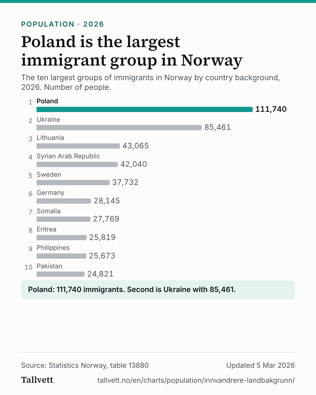 Poland is the largest immigrant group in Norway
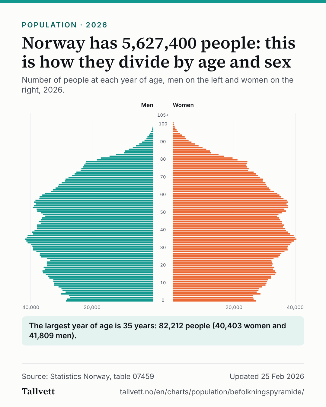 Norway has 5,627,400 people: this is how they divide by age and sex
 Oslo is Norway's largest municipality, with 728,714 people
 Norwegian women have 1.48 children on average, down from 2.75 in 1968
 Ukraine is the immigrant group that has grown most in ten years
 17 out of 100 residents are 67 or older
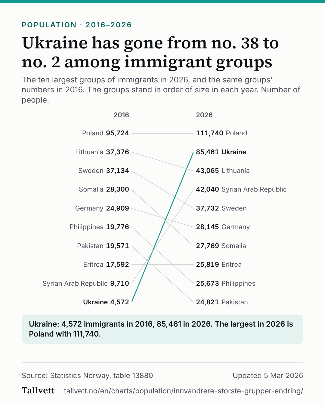 Ukraine has gone from no. 38 to no. 2 among immigrant groups
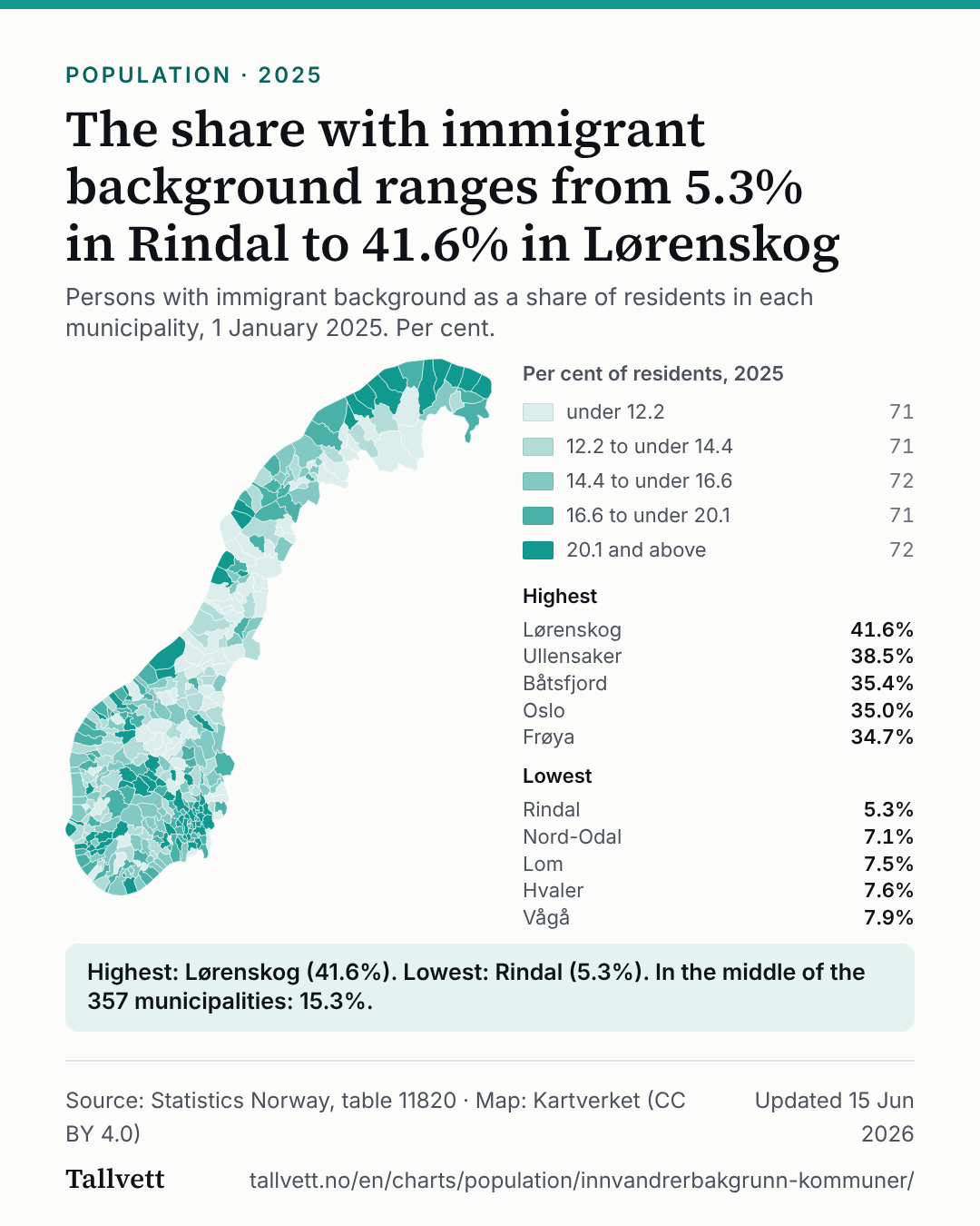 The share with immigrant background ranges from 5.3% in Rindal to 41.6% in Lørenskog